

Latest News
Global Mobile Phone Users: A Decade of Changes
08.07.2015, http://www.viewsoftheworld.net/
A global shift in predominance of mobile/cell phone ownership in the last decade has seen low-income countries reach near ubiquitous levels. Using 11 years of compiled census data from each country worldwide, Andrew Bastawrous, Iain Livingstone and Benjamin Hennig analysed the global picture of cell phone ownership and used density-equalizing cartograms to depict this change. This cartogram animation shows a decade of change in the use of mobile phones:
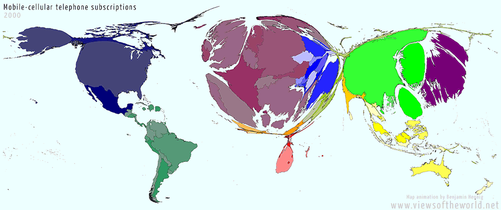
[http://www.viewsoftheworld.net/, July, 2015]
An integrated learning managment system for location-based mobile learning
16.03.2015, Funchal, Madeira
This paper is presented at Mobile Learning 2015 conference in Funchal Madeira. The papper discusses the relevance and challenges of a location-based learning platform that supports mobile learning in education. We present the design of an integrated management system for location-based mobile learning. Independent of the taught subject, the objective of the system consists of an easy-to-understand user interface for both - teachers and students. More on ...
HTML5 Geolocation API
05.12.2014, ETH Zürich, Hönggerberg
The studentd app of OMLETH requires to locate the user's position. Due to HTML5 implementation of this app, the geolocation operates with
HTML5 Geolocation API .
[w3schools, wikipedia, w3org]
- Part 1 HTML5 Geolocation API – how accurate is it, really?
- Part 2 How Accurate is HTML5 Geolocation, really? Part 2: Mobile Web
MEVAP-Method
04.12.2014, ETH Zürich, Hönggerberg
MEVAP stands for Modellieren, Erfassen, Verarbeiten, Analysieren, Präsentieren and is a general curriculum of a gis project. E (Erfassung) stands for data collection and is the location-based mobile learning part of MEVAP. As part of the GIS seminar of Geography Didactics MEVAP was presented and performed by workshop method in 3 hours by Christian Sailer. A guideline of this event is available here.
Lecture "Mit GIS auf Exkursionen"
24.11.2014, University Zürich, Campus Irchel
During the series of the "Ringvorlesung der Universität von Zürich und der ETH Zürich zum Thema GeoFachwissenschaften" I got invitated to present the last then year experiences of gis as method in K12 and Higher Education especially in Excursions.
Launch of geolearning.ch
01.12.2014, ETH Zürich, Hönggerberg
The final version of the submitted and already accepted paper "An Integrated Learning Management System For Location-Based Mobile Learning" by Sailer, Kiefer and Raubal has been sent as Conference proceeding to the 11th International Conference on Mobile Learning 2015 (ML 2015). Therefor we launched geolearning.ch to inform our recent implementations and update our current work in research.